
The Cully, or Byker Culvert to give it it's Sunday name, was built in 1907 to collect sewage and provide drainage to the area surrounding it. It was built by constructing a concrete arch over a length of the Ouseburn. The Ouseburn, a tributary of the Tyne, runs through a steeply sloping valley and the arch was built along the bottom of that, totally covering the river for a length of about half a mile. The arch was then covered with soil to a depth of 100ft.
The area on top of this soil was later used as a landfill area so the covering is now even thicker. This usage gave rise to one of the area's local names - the tip. It is more commonly known now as the Stadium as there is a tatty running track and a football pitch in the middle of it. Mmmm smell those toxins.
During World War II, Newcastle was a prime target for German bomber raids due to the numerous shipyards, armaments factories, coal tranportation facilities located here etc and it was decided to use the Cully as an air raid shelter, as they did with the Victoria tunnel.
It fell into disuse after that, only being used by local kids as a place to play which is exactly how I find out about it. After our successful trip to the Victoria Tunnel the other week we decided we should visit the Cully on an Official New Links Unofficial Tunnel Tour. I hadn't been down the Cully for over 20 years and didn't even know if it was still accessible but in the interests of local history we had to find out!
You may notice the faces are blurred on the pictures. This is because we weren't sure about the legality of our visit and I couldn't be bothered to add ninja masks! There were no keep out signs, warning signs or dire warnings of death by Alsatian. Nor was there any attempt to seal it off which would be easy to do as right near the beginning you enter through a normal door sized entry - with no door. So I reckon we are just practicing our right to ramble under this Government's open country laws. However as m0$$@d and the C14 read New links we are going to err on the side of caution! Click on the small images for their flickr page. There's extra info in the ALT on each one too.
 Naturally we assembled at a local hostelry to ensure we were suitably refreshed. This time it was The Ship, just around the corner from the Cully.
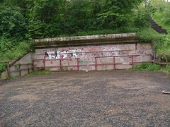 This looks like the original entrance to the Cully. If you look closely at the back wall you can see the top of a filled in arch. The flat area is immediately above the current (downstream) entrance of the Cully.
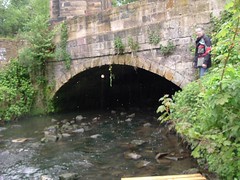 This is the point were the Ouseburn exits the Cully. It is also the point where we are going in. MAP
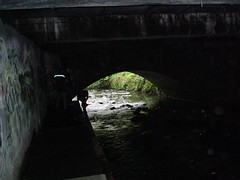 This is looking downstream immediately after entering the Cully. We had to scramble across strategically placed, albeit slime covered, rocks to get inside the arch then jump up onto a little concrete quay, which is where this picture is taken from.
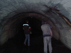 This is the first proper part of the Cully. At this point I was thinking it looked a lot smaller than I remembered it.
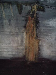 This is one of ILuvNufc's childhood bogeys - the toxic mass beings that ooze out of the walls. I must point that out at this juncture that ILN is square as he was not there. :)
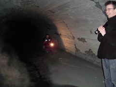 The tunnel has now widened out into the huge space that I remember. I'm no good at estimating sizes and none of us brought a tape measure so huge will have to suffice.
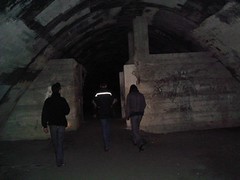 The structure immediately ahead is what we used to call the shop. It is actually a blast wall built across the width of the tunnel to prevent bomb damage spreading further up the tunnel. There are 2 of these in the tunnel.
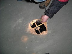 The floor of the tunnel is filled with lots of holes like these and quite a few manhole sized ones. The water you see below is the Ouseburn. We think the floor was added in WWII as there is a cutaway section on a plaque in Warwick Street showing the Cully when it was built and there was no floor then.
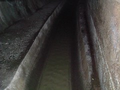 The channel above runs parallel with the Ouseburn and just under the floor. There were side culverts on the cutaway section so this is probably part of the initial 1907 construction.
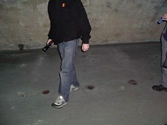 There were a series of pipes going through the floor here. We reckon these were possibly the remains of toilets from WWII.
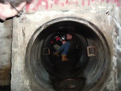 Every now and then large pipes would protrude from the sides of the tunnel. These all point to the surrounding housing areas so are probably street drainage. Most of them were filled with various coloured, evil smelling gunk but this one was fairly dry and a wall could be seen a short way in. Al nominated himself as tunnel rat and went and had a look but the wall completely sealed the pipe. Curiously the pipe had climbing rungs even though it runs horizontally. This prompted conjecture of a Zelda like rotating room sort of thing. We couldn't find any switches though so that knocked that one on the head.
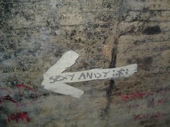 Sexy Andy is, apparently, this way. We must have passed him in one of the side tunnels as there was no sign of him.
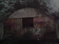 The hole in the wall ahead leads through to a little square room which was absolutely minging of foisty, damp things. Hippy Tony and I, who had been down here before, declined the chance to scramble through a slimy hole so we stood and watched Bungers and Al do it instead.
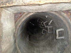 The square room contained nothing but foisty, damp things (hence the minginess) and this vertical shaft leading to a manhole above. Daylight can be seen through the gaps in the cover. Assuming the manhole cover would be securely fastened we turned around and retraced our steps.
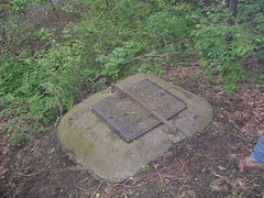 Once we got back out we re-walked the route of the tunnel, this time tracing it's route through the streets to the point where the Ouseburn entered it. More to the point, we knew where the manhole was having seen other kids go down it in the past. Or something. Probably. Amazingly while there was a bar across the top of the cover there was no padlock on the bar - it was completely unsecured. MAP
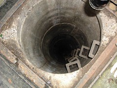 In fact, such was it's state of unsecuredness, it opened after we just looked at it for a few seconds. Honest officer. We closed it after we decided against going back through again due to the fact that everyone's batteries had pretty much died - even Al's alleged mini nuclear reactor thing.
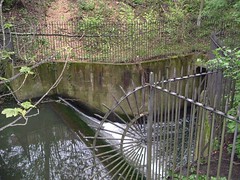 The final picture is of a little weir, over which the Ouseburn goes just before entering the tunnel. This is just down the hill from the manhole cover.
And that is the end of the Official New Links Unofficial Tunnel Tour. It is rumoured the next tunnel escapade may involve the use of sledge hammers. Yay!
3 comments:
Quality linkage. Quality report.
That looks like a contender for Post of the Month™!!
Well done sir!
Post of the year more like! And we are of course still waiting for the Victoria Tunnel report. :)
I think this report is one of the best I've ever seen. He should do this full time.
Post a Comment